ShopDreamUp AI ArtDreamUp
Deviation Actions


Suggested Deviants


Suggested Collections


![Ino Yamanaka [Chinese New Year costume] Render 3](https://images-wixmp-ed30a86b8c4ca887773594c2.wixmp.com/f/a05d0b14-98d7-40d8-b9dd-6b0149bdeab0/dd0fous-5af8387a-2b87-41ed-9e50-9385d50db0af.png/v1/crop/w_184,h_184,x_0,y_2,scl_0.28615863141524/ino_yamanaka__chinese_new_year_costume__render_3_by_dp1757_dd0fous-92s-2x.png?token=eyJ0eXAiOiJKV1QiLCJhbGciOiJIUzI1NiJ9.eyJzdWIiOiJ1cm46YXBwOjdlMGQxODg5ODIyNjQzNzNhNWYwZDQxNWVhMGQyNmUwIiwiaXNzIjoidXJuOmFwcDo3ZTBkMTg4OTgyMjY0MzczYTVmMGQ0MTVlYTBkMjZlMCIsIm9iaiI6W1t7ImhlaWdodCI6Ijw9Njc3IiwicGF0aCI6IlwvZlwvYTA1ZDBiMTQtOThkNy00MGQ4LWI5ZGQtNmIwMTQ5YmRlYWIwXC9kZDBmb3VzLTVhZjgzODdhLTJiODctNDFlZC05ZTUwLTkzODVkNTBkYjBhZi5wbmciLCJ3aWR0aCI6Ijw9NjQzIn1dXSwiYXVkIjpbInVybjpzZXJ2aWNlOmltYWdlLm9wZXJhdGlvbnMiXX0.9sO8pasLMdOZd83D0vl2XH6pol8DGUHi-91tldolzUE)
![Ino Yamanaka [Chinese New Year costume] Render 3](https://images-wixmp-ed30a86b8c4ca887773594c2.wixmp.com/f/a05d0b14-98d7-40d8-b9dd-6b0149bdeab0/dd0fous-5af8387a-2b87-41ed-9e50-9385d50db0af.png/v1/crop/w_92,h_92,x_0,y_1,scl_0.14307931570762/ino_yamanaka__chinese_new_year_costume__render_3_by_dp1757_dd0fous-92s.png?token=eyJ0eXAiOiJKV1QiLCJhbGciOiJIUzI1NiJ9.eyJzdWIiOiJ1cm46YXBwOjdlMGQxODg5ODIyNjQzNzNhNWYwZDQxNWVhMGQyNmUwIiwiaXNzIjoidXJuOmFwcDo3ZTBkMTg4OTgyMjY0MzczYTVmMGQ0MTVlYTBkMjZlMCIsIm9iaiI6W1t7ImhlaWdodCI6Ijw9Njc3IiwicGF0aCI6IlwvZlwvYTA1ZDBiMTQtOThkNy00MGQ4LWI5ZGQtNmIwMTQ5YmRlYWIwXC9kZDBmb3VzLTVhZjgzODdhLTJiODctNDFlZC05ZTUwLTkzODVkNTBkYjBhZi5wbmciLCJ3aWR0aCI6Ijw9NjQzIn1dXSwiYXVkIjpbInVybjpzZXJ2aWNlOmltYWdlLm9wZXJhdGlvbnMiXX0.9sO8pasLMdOZd83D0vl2XH6pol8DGUHi-91tldolzUE)
![[NEW] Ino Yamanaka | Ninja Tribes | Render](https://images-wixmp-ed30a86b8c4ca887773594c2.wixmp.com/f/a05d0b14-98d7-40d8-b9dd-6b0149bdeab0/ddrpkgp-3f819096-4303-4bfe-87b7-793d50a62680.png/v1/crop/w_184,h_184,x_0,y_0,scl_0.1796875/_new__ino_yamanaka___ninja_tribes___render_by_dp1757_ddrpkgp-92s-2x.png?token=eyJ0eXAiOiJKV1QiLCJhbGciOiJIUzI1NiJ9.eyJzdWIiOiJ1cm46YXBwOjdlMGQxODg5ODIyNjQzNzNhNWYwZDQxNWVhMGQyNmUwIiwiaXNzIjoidXJuOmFwcDo3ZTBkMTg4OTgyMjY0MzczYTVmMGQ0MTVlYTBkMjZlMCIsIm9iaiI6W1t7ImhlaWdodCI6Ijw9MTAyNCIsInBhdGgiOiJcL2ZcL2EwNWQwYjE0LTk4ZDctNDBkOC1iOWRkLTZiMDE0OWJkZWFiMFwvZGRycGtncC0zZjgxOTA5Ni00MzAzLTRiZmUtODdiNy03OTNkNTBhNjI2ODAucG5nIiwid2lkdGgiOiI8PTEwMjQifV1dLCJhdWQiOlsidXJuOnNlcnZpY2U6aW1hZ2Uub3BlcmF0aW9ucyJdfQ.bmLt0ggitBylxGZVXvUVHb72HKvd9XzyMQ42FeqCZso)
![[NEW] Ino Yamanaka | Ninja Tribes | Render](https://images-wixmp-ed30a86b8c4ca887773594c2.wixmp.com/f/a05d0b14-98d7-40d8-b9dd-6b0149bdeab0/ddrpkgp-3f819096-4303-4bfe-87b7-793d50a62680.png/v1/crop/w_92,h_92,x_0,y_0,scl_0.08984375/_new__ino_yamanaka___ninja_tribes___render_by_dp1757_ddrpkgp-92s.png?token=eyJ0eXAiOiJKV1QiLCJhbGciOiJIUzI1NiJ9.eyJzdWIiOiJ1cm46YXBwOjdlMGQxODg5ODIyNjQzNzNhNWYwZDQxNWVhMGQyNmUwIiwiaXNzIjoidXJuOmFwcDo3ZTBkMTg4OTgyMjY0MzczYTVmMGQ0MTVlYTBkMjZlMCIsIm9iaiI6W1t7ImhlaWdodCI6Ijw9MTAyNCIsInBhdGgiOiJcL2ZcL2EwNWQwYjE0LTk4ZDctNDBkOC1iOWRkLTZiMDE0OWJkZWFiMFwvZGRycGtncC0zZjgxOTA5Ni00MzAzLTRiZmUtODdiNy03OTNkNTBhNjI2ODAucG5nIiwid2lkdGgiOiI8PTEwMjQifV1dLCJhdWQiOlsidXJuOnNlcnZpY2U6aW1hZ2Uub3BlcmF0aW9ucyJdfQ.bmLt0ggitBylxGZVXvUVHb72HKvd9XzyMQ42FeqCZso)


You Might Like…


Description
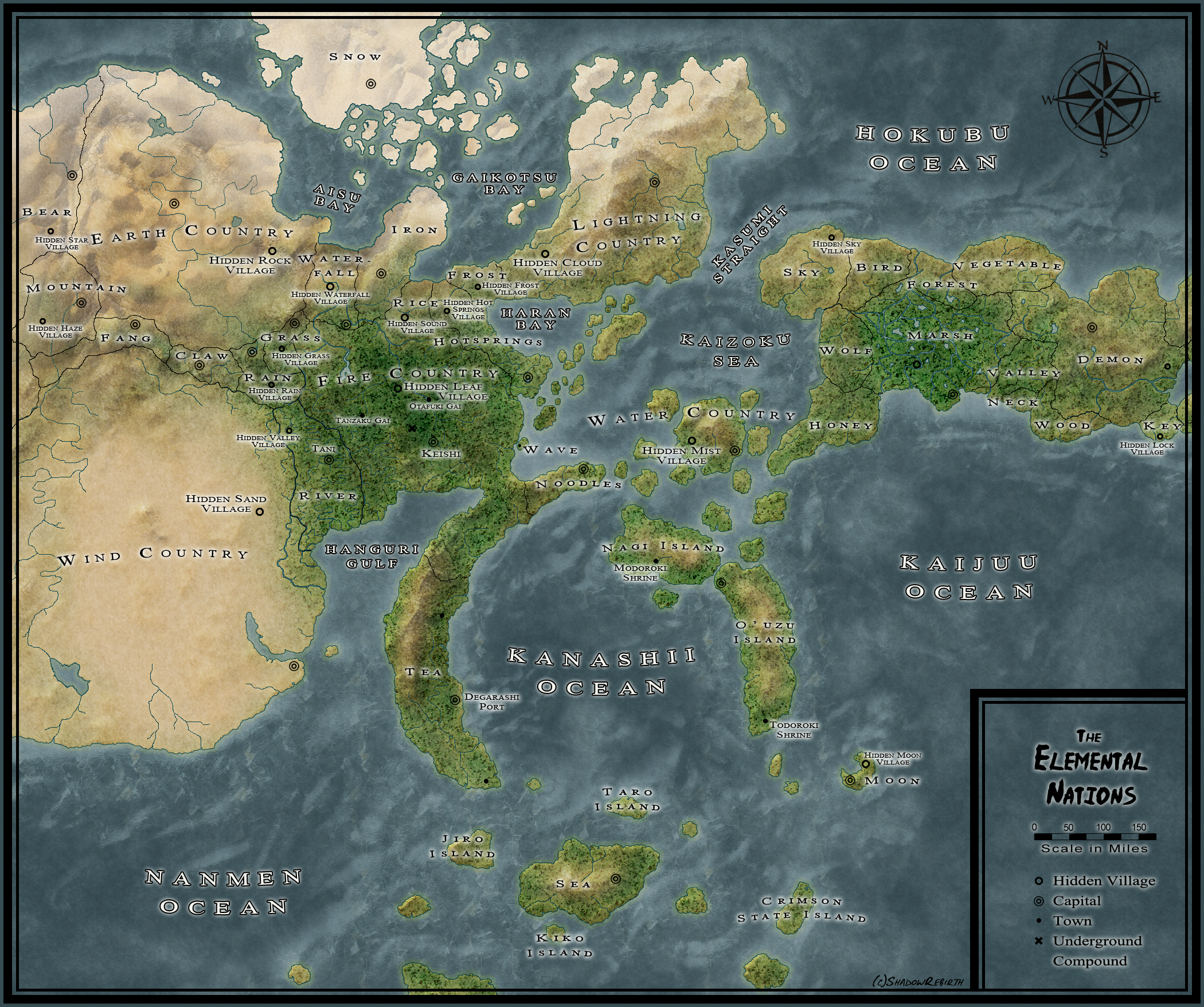
A geographical map of the Naruto world, made for my fanfiction Worth Dying For.
Basically, I couldn't find any really good, up-to-date maps of the Elemental Nations, so I wound up compiling all the ones I could find and making my own. Most of the countries and hidden villages are all from canon, though some (ie everything on the eastern continent except for Marsh and Demon Country) were placed at random. All the names are from canon though, minus Keishi. Same thing for village and capital locations - what I could find from canon are in their place, the rest were placed at random. None of the names of bodies of water are canon, and I'm far from being able to speak Japanese so meaning-wise they might be a bit off.
If anyone notices any countries or location that are wrong, please tell me so that I can fix it!
Also, the scale is "accurate", based off the idea that a long caravan can cover around 20 miles a day (based on estimates from old covered wagons + terrain type + all animals being pretty sturdy in the shinobi world) and that it took around 4 day for that caravan to go from Leaf to Keishi, making that distance about 80 miles.
The political version of this map can be found here.
Edit Feb 13, 2013: Changed the locations of a few minor countries.
To anyone asking: I don't mind at all if you use these maps for your stories, so long as proper credit is given.
Image size
2100x1757px 6.16 MB
Comments55
Join the community to add your comment. Already a deviant? Log In
yo love this!